Jump to:
Sabancaya Volcano Deformation
Downconversion in Gravity Meters
Cerro Negro Gravity
Kilauea Gravity Network
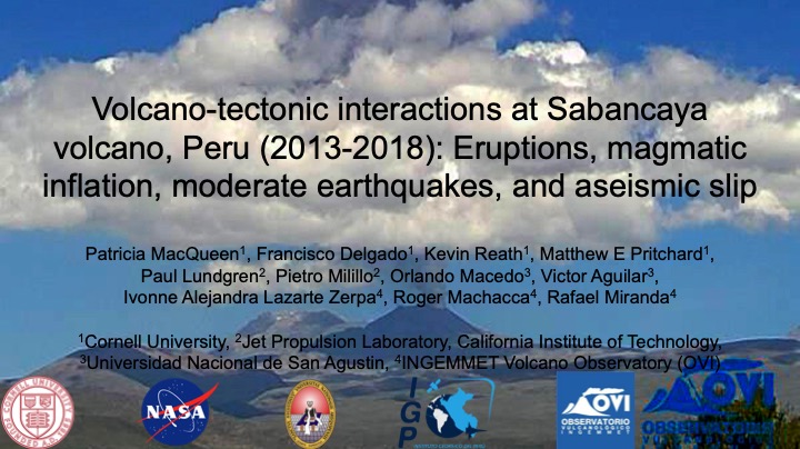
Magmatic inflation, tectonic earthquakes, and fault creep at Sabancaya Volcano, Peru
(Research conducted at Cornell University)
A burst of strong earthquakes in 2013 preceded the most recent eruptive episode at Sabancaya volcano (2014-present), and our later InSAR observations determined that magmatic inflation began around the same time – located north of Sabancaya, centered on the extinct volcano Hualca Hualca. InSAR observations also revealed fault creep on multiple faults northwest of Sabancaya. So were the earthquakes and fault creep related to the magmatic inflation?
In this study I calculated an InSAR time series spanning 4 years using data from Sentinel 1, inverted for best-fit deformation sources for the inflation source and two earthquakes, and modeled Coulomb static stress changes. I analyzed these results along with additional data from co-authors, including InSAR data (in total spanning 27 years), satellite observed thermal and SO2 degassing anomalies, local earthquake locations, and ground based emissions locations.
Our study determined that magmatic intrusions destabilized local tectonic faults rendered unstable by high regional pore fluid pressures. High pore fluid pressures also likely created ideal conditions for fault creep driven by static stress transfer from intrusions at depth. The inflation, offset from Sabancaya yet active during an eruptive period, points to a vertically and laterally complex magmatic system underlying the volcano.
Publications and presentations:
- MacQueen, P., Delgado, F., Reath, K., Pritchard, M., Bagnardi, M., Milillo, P., Lundgren, P., Macedo, O., Aguilar, V., Ortega, M., Anccasi, R., Lazarte Zerpa, I., Miranda, R. (2020). Volcano-tectonic interactions at Sabancaya volcano, Peru: eruptions, magmatic inflation, moderate earthquakes, and fault creep. JGR – Solid Earth. https://doi.org/10.1029/2019JB019281.
- MacQueen, P., Delgado, F., Reath, K., Pritchard, M., Bagnardi, M., Milillo, P., Lundgren, P., Macedo, O., Aguilar, V., Zerpa, I., Machacca, R., Miranda, R. (2019). Volcano-tectonic interactions at Sabancaya volcano, Peru: Eruptions, magmatic inflation, moderate earthquakes, and aseismic slip. 2019 EUROVOLC Etna Summer School on Sub-Surface Volcanic Processes.
- MacQueen, P., Delgado, F., Reath, K., Pritchard, M., Lundgren, P., Milillo, P., Macedo, O., Aguilar, V., Zerpa, I., Machacca, R., Miranda, R. (2018). Volcano-tectonic interactions at Sabancaya volcano, Peru (2013-2018): Eruptions, magmatic inflation, moderate earthquakes, and aseismic slip. 2018 AGU Fall Meeting.
- MacQueen, P., Delgado, F., Pritchard, M., Amelung, F., Arnold, D., Biggs, J., Ebmeier, S., Henderson, S., Poland, M., Sansosti, E., Wauthier, C. (2018). Satellite-based monitoring of long term and rapidly changing volcano deformation: Updated results from the CEOS Latin America Pilot Project. 2018 UNAVCO Science Workshop.
Using down conversion as a tool to detect non-linearity and noise levels in continuous gravity meters
(Research conducted at Micro-g LaCoste)
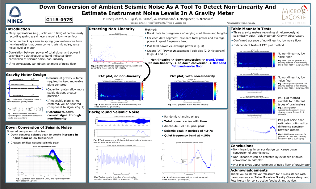
What do you do when you want to know if your gravity meter is sadly nonlinear and measuring gravity2 instead of nice linear gravity? Turn lemons into lemonade, and use the down conversion of ambient noise the nonlinearity creates to detect the non-linearity! And, as an added bonus, get an upper estimate of the noise floor as well! For more, see my 2015 AGU poster on this work below.
Presentation:
MacQueen, P., Hugill, A., Billson, R., Constantino, A., MacQueen, J., Niebauer, T. (2015). Down Conversion of Ambient Seismic Noise As A Tool To Detect Non-Linearity And Estimate Instrument Noise Levels In A Gravity Meter. Abstract G11B-0975. 2015 AGU Fall Meeting. (Outstanding Student Presentation Award)
Connected magma plumbing system at Cerro Negro Volcano, Nicaragua
(Research conducted at Simon Fraser University)
Cerro Negro is one of the youngest volcanoes in the world – it first erupted in 1850! Since then, it’s been quite active, with eruptions on average every 6 to 7 years, occasionally dumping ash on nearby León, one of Nicaragua’s largest cities. So should we consider this volcano a short-lived feature, another volcano in a cornfield like Parícutin? Or is Cerro Negro the beginnings a much larger volcano, a very young Mt. St. Helens?
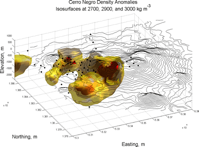
The answer I found pointed to a bit of both. With my co-authors, I measured small changes in gravity on and around Cerro Negro and neighboring volcanic cones, and inverted the gravity measurements to construct a 3-D model of the density changes underneath the volcano. The model showed high density anomalies, that I interpreted as cooled magma, connecting Cerro Negro and its neighbors Las Pilas-El Hoyo and Cerro La Mula. I deduced that Cerro Negro represented the latest cone in a large volcanic complex – a small feature tapping a larger magma system. My research suggests that Cerro Negro and its sibling volcanoes are here to stay, and well worth keeping an eye on!
Publications and presentations:
- MacQueen, P., Zurek, J., Williams-Jones, G. (2016). Geophysical investigations of Cerro Negro volcano, Nicaragua: Insights on magmatic plumbing systems. Journal of Volcanology and Geothermal Research. pp. 375–384. http://dx.doi.org/10.1016/j.jvolgeores.2016.09.002.
- MacQueen, P., Williams-Jones, G, Zurek, J.. (2013). Geophysical Investigations of Cerro Negro Volcano, Nicaragua: Insights on magmatic plumbing systems. International Association of Volcanology and Chemistry of the Earth’s Interior (IAVCEI) 2013 Scientific Assembly.
- MacQueen, P., Zurek, J., Williams-Jones, G. (2013). Gravity data reveals intimate connection between magma plumbing system and tectonics at Cerro Negro. 2013 Pan American Advanced Studies Institute (PASI) on Magma-Tectonic Interactions in the Americas.
Optimizing the microgravity network at Kilauea Volcano, Hawaii
(Research conducted at the University of Oregon and Simon Fraser University)
Volcanoes are notoriously tricky places to do science – with craters, steep slopes, and sometimes molten lava, you can forget about having a nice pretty grid of consistent measurement locations for a time-lapse gravity survey! With gravity measurement locations limited to easily accessed road and trail-side locations, it can be difficult to determine how well your network can detect mass changes of different sizes and depths. My research on the time-lapse gravity network at Kilauea Volcano in Hawaii assessed the abilities of the current network by calculating the gravity change for simulated magmatic intrusions of a range of sizes and depths. I also used this technique to recommend placement of new measurement locations to best expand the network’s coverage. Truly, a matter of great gravity.

Publications and Presentations:
- MacQueen, P. (2011). Forward Modeling to Assess and Improve Gravity Network Geometry at Kilauea Volcano, Hawai`i. Oregon Undergraduate Research Journal, 1(1), 24-44. http://dx.doi.org/10.5399/uo/ourj.1.1.1551.
- MacQueen, P., Cashman, K., Poland, M., Schmidt, D., Williams-Jones, G. (2012). Using Forward Modeling to Optimize the Geometry of Geophysical Networks at the Summit of Kilauea Volcano: A Matter of Great Gravity. AGU Chapman Conference on Hawaiian Volcanoes: From Source to Surface.
- MacQueen, P. (2011). Using Forward Modeling to Optimize the Geometry of Geophysical Networks at the Summit of Kilauea Volcano: A Matter of Great Gravity. University of Oregon Undergraduate Symposium.
